 t-afeth-00002
← Collection
images
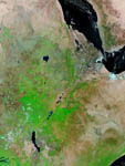
Eastern Africa by Terra satellite
- Reference
- t-afeth-00002
- Date
- 2007-02-09
False-color image taken by the satellite Terra in january 2003. Here is the eastern area of Africa showing the Afar depression, the junction of three tectonic plates.Most of the image shows Ethiopia crossed by the Rift.The vegetation is bright green, naturally bare soil is pinkish tan, burn scars are reddish brown, water is dark blue or black, and clouds are light blue or white. NB : border lines are marked
Contact →