
Photo Agency - Astronomy - Space - Nature


> Venus by Magellan spacecraft: Gula Mons volcano
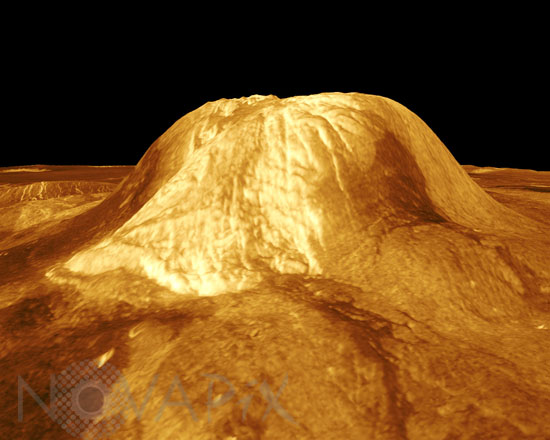
Venus by Magellan spacecraft: Gula Mons volcano
author: Nasa/JPL/Novapix
reference: a-ven06-00031
Image Size 300 DPI: 10 * 8 cm
Gula Mons is displayed in this computer-simulated view of the surface of Venus. The viewpoint is located 110 kilometers (68 miles) southwest of Gula Mons at the same elevation as the summit, 3 kilometers (1.9 miles) above Eistla Regio. Lava flows extend for hundreds of kilometers across the fractured plains. The view is to the northeast with Gula Mons appearing at the center of the image. Gula Mons, a 3 kilometer (1.9 mile) high volcano, is located at approximately 22 degrees north latitude, 359 degrees east longitude in western Eistla Regio. Magellan synthetic aperture radar data is combined with radar altimetry to produce a three-dimensional map of the surface. Rays cast in a computer intersect the surface to create a three-dimensional perspective view. Simulated color and a digital elevation map developed by the U.S. Geological Survey are used to enhance small-scale structure. The simulated hues are based on color images recorded by the Soviet Venera 13 and 14 spacecraft.
Keywords for this photo:
ASTRONOMY - EISTLA REGIO - FALSE COLOR - GULA MONS - MAGELLAN - PLANET - RADAR - VENUS - VOLCANO -
Contact : Stéphane Aubin +33-(0)9-51-26-53-76
© Novapix - All rights reserved